|
Basic map reading
Map Scale
As mentioned previously the scale of the map indicates how long a distance measured on the map is in the terrain.
If a map has the scale 1:50000, and you are measuring the distance from where you are to where you will travel to be 6 cm, your walking distance to that point will be 3 kilometres.
But this distance is in reality just the distance by air.
The real distance could be much longer depending on how the terrain varies in height. Besides trails seldom runs in a straight line. You will often have to add 20 to 30 percent to the measured length to get close to the real travel length.
A person will normally travel 3-5 kilometres per hour, depending on his shape and the terrain.
As a rule one add 15 minutes to every 100 meters of ascent (in real bad weather this rule also apply going down hill).
If you measure 3 kilometres on your map and the height difference is 300 meters, you could expect to walk 1 hour and 45 minutes ++.
Some maps even show trails with a number indicating estimated walking time.
Contour lines
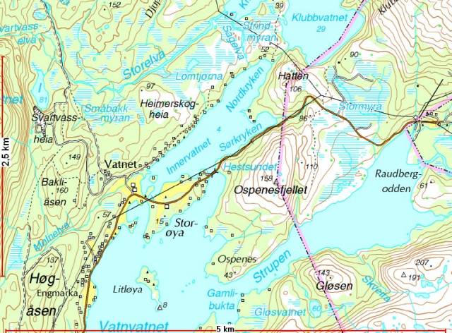
The countor lines (brown colour) show the height differences in the terrain.
Widely spread lines means fairly flat terrain, while lines close together indicates steep terrain.

Remember that the height between these lines is 20 meters (N50 maps) and smaller drops don’t show.
On the map picture above left there could easily be a steep impassable ridge between the countor lines which don’t show on the map, because it is lower than 20 meters.
The N50 maps sometimes have extra, dotted contour lines every 10 meters in height to help you in rough terrain.
Flat terrain is obviously easier and faster to walk in, and often the longer way around a mountain is faster than going over it. This is something to have in mind when choosing a route.
Countour lines for every 100 meters are slightly bolder then the normal countor lines.
For a beginner it is not always easy to see wich way a creek runs or if it is a ridge or valley you are looking at, but this will be better with a little training. Countour lines bend inwards a valley and outwards at a ridge.
Map colours
Brown colour shows height (countour lines) as mentioned above.
Green areas usually depict forests and white areas non forested area, although small groups of trees and low scrubs could also be found in the white areas (often along small creeks/rivers in a valley bottom).
Light blue flats, lines or areas with blue and white stripes, indicates water bodies and bogs/marshes. While most bogs are passable some could take longer to cross than go around. I have often taken the short route across a bog just to find out that it actually took longer to cross than to go around because they was so wet (quaking bog) I stood in danger of going trough it some places. Finding a route trough them was time consuming.

Red lines usually shows main roads and pinkish areas shows built up areas. Yellow areas show farmland and small squares depict houses or cabins. Far away from people knowing where these cabins, shacks or “gamme” (small black triangles) are could be a life saver in an emergency.
But remember, some of these cabins could actually be just ruins.
The longer since the map was photographed the more likely it is that some of the man made features are altered or removed.
Black colour is used on man made structures and text.
Finding your coordinates
The N50 maps are divided in squares of 1 square kilometre each. This is the grid lines of the UTM system. The lines running east-west are paralell to the equator and the lines running north-south are lines tought to be running trough the poles.
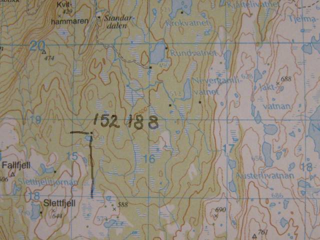
Each square could be described as a number code, the numbers written in large font in the margin.
As an example the cabin in the picture below lies in square 1518. You always read the numbers east and then north.
A rule to remember it by from the army was; along the skirt bottom and then up to heaven.

These squares could be further divided, usually in 10 parts (each part is 100m).
From this we can read a 6 digit position that will be understood by the rescue service.
The cabin`s coordinates is then 152188. I also know that the maps name is JUNKERDAL.
The full coordinate to the rescue service is then; JUNKERDAL 152188.
|