|
Basic use of the compass
The compass

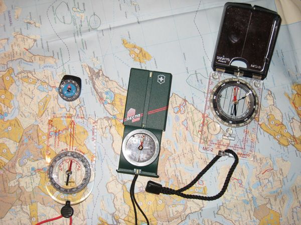
The basic compass is made up mostly by three parts, the base, the needle housing and magnetic needle (which always point north, magnetic north that is).
The base mostly has a scale for measuring lengths and finding your coordinates. A direction of travel arrow is also part of the base plate.
The compass housing has an orienting arrow and orienting lines (it also have a 360° or 400 gon dial).
Some compasses also have a mirror, magnifier or other extra features, or they lack everything but the needle and dial (button compass).
A compass could be disturbed by local magnetic attraction. Iron ore, vehicles, your gun or knife could affect the direction the needle points. When using a compass you should avoid being close to any metal which could interfere with your bearings.
Finding the travel direction
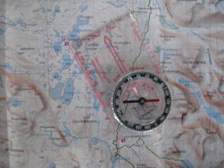
The procedure for finding a compass course is as follows. You are walking from A to B on the map. A is the purple spot south on the map. Actually Tarraluoppal in Padjelanta.
Point B is Tuottar cabins.

Lay the compass edge from A to B. Turn the needle housing until the lines in the compass housing matches the north/south grid on the map.

Holding the compass in your hand turn around (your body) until the needle is parallel with the orienting arrow in the needle housing.

The compass march arrow will now point in your travel direction.
You could of course orient your map to point north first, but it isn’t necessary.
I have just turned the compass on the map for eduqational purpose.
Aiming off

When finding the compass course it is sometimes wise to use what is called “aiming off”.
This requires the target to be found at a linear feature (leading line) you could follow to your destination. This could be a river, power line, shore line or trail.
Let’s imagine your destination is a “gamme” (sod house) by a small creek, point B on the picture above.
You find the bearing to the “gamme”, red line on the picture, follow the course and after a while you reach the creek.
But there is no “gamme”. You have clearly missed the target.
The question then arises; should you go up or down the river to find the hut?
To avoid such situation “aiming off” is handy.
Deliberately aim slightly, 10 degrees, to one side of the target, point C on the picture. When you reach the leading line, in this case a creek, you know what way to go to reach the shelter.
You could of course just follow the creek from point A to the small pond to the west and then go to the next ponds south-west of that, and follow the creek all the way to the “gamme” without using your compass at all.
But the picture is merely for demonstration of the technique.
Triangulation
If you are unsure of your position it could be found based on two or more clearly recognized landmarks.
Orient your map North-South.
Then locate two landmarks (preferably 90° (100gon) apart). Take a bearing to the first landmark.
Lay the compass on the map with its side pointing agaist the landmark you took your bearing to. Turn the compass around until the needle and orienting arrow match. Mark the line on yor map.
Now do the same prosedure using the other landmark.
Your position will be where the two lines intersect. As a control you could also use a third landmark. You will probably notice that the lines don`t meet exactly at the same point, but makes a triangle. This is due to inaccuracy in taking the bearing, turning the compass or drawing the line (or all three). But somewhere inside that triangle is your position.
I have never used the above method other than in my work, and then with a theodolite, as I never had any need to do it.
Declination
Easily explained it is the difference between true north (map north) and magnetic north. Declination differs around the globe and within each country, and also over time, due to the magnetic north moving.
In Finnmark County the declination is as much as 11 degrees east, and should be adjusted for (the county is also the flattest of the three northern counties). 10 degrees declination makes you miss the target with 1200 meters on a 6 kilometres stretch.
Most other places you need not to bother with the problem. Not because the declination doesn’t matter, but the terrain is channelling and will keep you on course most of the time.
For a more thorough explanation I suggest a search on Google.
To be real good with the compass you have to use it or train regularely. I don`t, so I`m no expert, but knowing the basics works for me.
|